Email distribution list: Click here to subscribe.
Local Notice to Mariners 12/2025
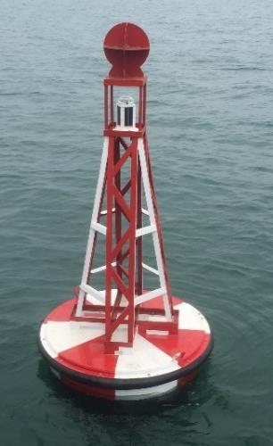
03/04/2025 – Y Fenai – Siart 1464 – Menai Strait – Chart 1464
Bar Caernarfon Bar
Mae cymhorthydd mordwyo Starboard Rhif C11 Fl(2)G.5s nawr yn ddangos ei siâp dydd priodol ac nawr yn arddangos ei nodweddion golau priodol.
53ᵒ09.88′ Gog 004ᵒ15.64′ Gor
Cynghorir morwyr bod yr hysbysiad hwn yn dileu Hysbysiad 10/25.
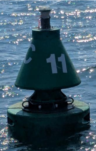
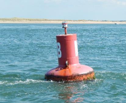
Aid to navigation Starboard C11 Fl(2)G.5s is now demonstrating its appropriate day shape and is exhibiting its appropriate light characteristics.
53ᵒ09.88′ N 004ᵒ15.64′ W
Mariners are advised that this notice herby cancels Notice 10/25.
Local Notice to Mariners 11/2025
01/04/2025 – Y Fenai – Siart 1464 – Menai Strait – Chart 1464
Bar Caernarfon Bar
Longddrylliad “Grampian Castle” Wreck
Mae Cardinal De sefydlog Nnewydd LFl(6) 10s (Castell Grampian) wedi’i osod ar longddrylliad “Grampian Castle”.
53ᵒ07.30′ Gog 004ᵒ22.99′ Gor
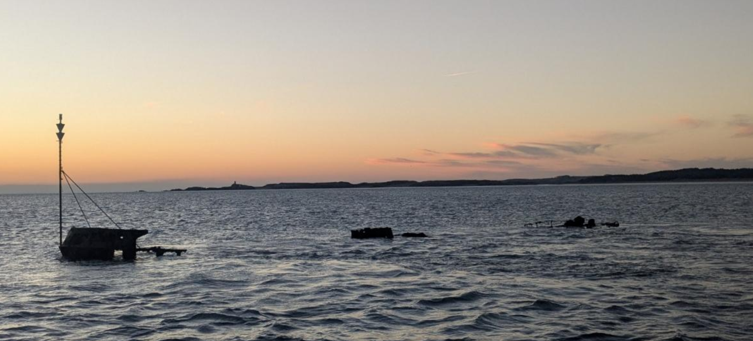
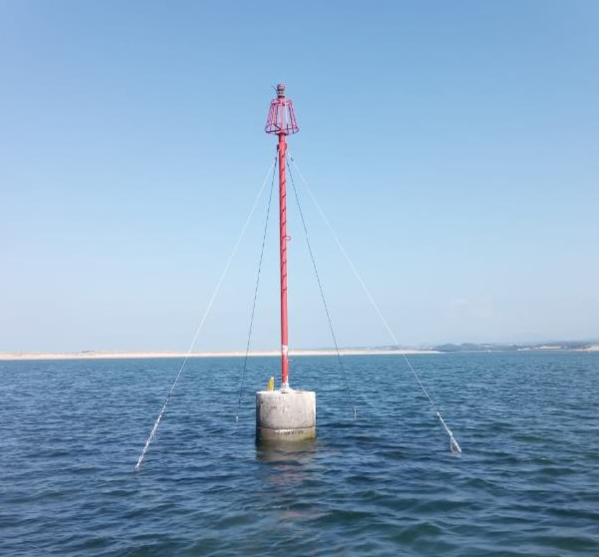
A new Fixed South Cardinal LFl(6) 10s (Grampian Castle) has been affixed to the wreck of the “Grampian Castle”.
53ᵒ07.30′ N 004ᵒ22.99′ W
Local Notice to Mariners 10/2025
13/03/2025 – Y Fenai – Siart 1464 – Menai Strait – Chart 1464
Bar Caernarfon Bar
Mae cymhorthydd mordwyo Starboard Rhif C11 Fl(2)G.5s nad yw’n dangos ei siâp dydd priodol ac nad yw’n arddangos ei nodweddion golau priodol.
53ᵒ09.88′ Gog 004ᵒ15.64′ Gor
Aid to navigation Starboard C11 Fl(2)G.5s is not demonstrating its appropriate day shape and is not exhibiting its appropriate light characteristics
53ᵒ09.88′ N 004ᵒ15.64′ W
Local Notice to Mariners 09/2025
19/03/2025 – Y Fenai – Siart 1464 – Menai Strait – Chart 1464
Swellies
Cynghorir morwyr bod yr hysbysiad hwn yn dileu Hysbysiad 08/25.
Mariners are advised that this notice herby cancels Notice 08/25.
Local Notice to Mariners 08/2025
19/03/2025 – Y Fenai – Siart 1464 – Menai Strait – Chart 1464
Swellies
Bydd dau fwi angori yn cael eu lleoli o amgylch Swelly Rock o 13:00 ar 21/03/25 hyd nes y cyhoeddir Rhybudd Morwriaeth yn dileu. Mae’r rhain er mwyn caniatáu mynediad ar gyfer gwaith atgyweirio arferol i’r AtoN.
Nid yw’r angorfeydd yn addas i’w defnyddio a gwaherddir Morwyr rhag defnyddio’r angorfeydd.
Cynghorir morwyr i fordwyo gyda gofal yn yr ardal hon.
Two mooring buoys will be situated surrounding Swelly Rock from 13:00 on the 21/03/25 until a cancellation Notice to Mariners is issued. These are to allow access for routine repairs works to the AtoN.
The moorings are not suitable for use and Mariners are prohibited from making use of the moorings.
Mariners are advised to navigate with caution in this area.
Local Notice to Mariners 07/2025
17/03/2025 – Y Fenai – Siart 1464 – Menai Strait – Chart 1464
Bae Caernarfon Bay
Cynghorir morwyr y bydd y cwch “Seven Guardian” yn cynnal arolwg gwyddonol ar raddfa fach (samplu cydio) rhwng y dyddiadau isod yn yr ardal Bae Caernarfon gan gynnwys y ffyrdd tuag at Gaernarfon. Bydd samplu yn cymryd oddeutu 2 ddiwrnod a bydd yn golygu gostwng ac adfer samplwr cydio gwaddod bach mewn lleoliadau ar draws y bae o borth Dinllaen i o amgylch Bar Caernarfon.
Gwaith arolwg: arolwg “benthig” Bae Caernarfon
Cyfnod yr Arolwg: 31/03/2025 – 18/04/2025
Hyd yr arolwg: 2 ddiwrnod
Amser yn yr orsaf: 15-60 munud
Lleoliadau sampl: ynghlwm
Cwch Arolwg: Severn Guardian
Dim ond ar gyfer y dyddiadau uchod y mae’r Hysbysiad hwn yn ddilys.
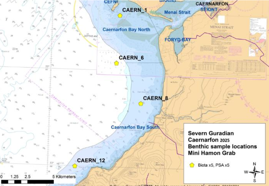
Mariners are advised that the vessel Seven Guardian will be undertaking a smallscale scientific survey (grab sampling) between the dates below in the Caernarfon Bay Area including the approaches to Caernarfon. Sampling will take approximately 2 days and will involve lowering and retrieving a small sediment grab sampler at locations across the bay from Porthdinllean to around the Caernarfon Bar.
Survey work: Caernarfon Bay benthic survey
Survey Period: 31/03/2025 – 18/04/2025
Survey duration: 2 days
Time on station: 15-60 mins
Sample locations: attached
Survey Vessel: Severn Guardian
This Notice is only valid for the above dates.
Local Notice to Mariners 06/2025
13/03/2025 – Y Fenai – Siart 1464 – Menai Strait – Chart 1464
Bar Caernarfon Bar
Mae cymhorthydd mordwyo Bwi Tramwyo L FL 10s ar ei safle priodol.
53ᵒ06.95′ Gog 004ᵒ25.14′ Gor
Aid to navigation Fairway Buoy L FL10s is now on station.
53ᵒ06.95′ N 004ᵒ25.14′ W
Local Notice to Mariners 05/2025
13/03/2025 – Y Fenai – Siart 1464 – Menai Strait – Chart 1464
Ynys Llanddwyn Island
Mae cymhorthydd mordwyo “Graig Dde dwyrain” Ynys Llanddwyn Cardinal De, Melyn a Du nawr ar ei safle priodol.
53ᵒ08.04′ Gog 004ᵒ24.46′ Gor
Cynghorir morwyr i fod yn ofalus iawn yn y ardal hwn.
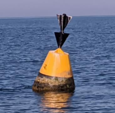
Aid to navigation Llanddwyn Island “South East Rock” South Cardinal, Y.B is on its appropriate station.
53ᵒ08.04′ N 004ᵒ24.46′ W
Mariners are advised to exercise extreme caution in this area.
Local Notice to Mariners 04/2025
12/02/2025 – Y Fenai – Siart 1464 – Menai Strait – Chart 1464
Bar Caernarfon Bar
Mae cymhorthydd mordwyo Port Rhif C12 Fl(2)R.10s nawr ar ei safle priodol.
53ᵒ08.49′ Gog 004ᵒ17.39′ Gor
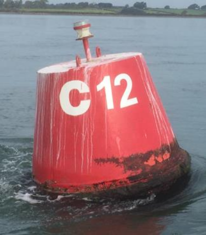
Aid to navigation Port No C12 Fl(2)R.10s is now on its appropriate station.
53ᵒ08.49′ N 004ᵒ17.39′ W
Local Notice to Mariners 03/2025
12/02/2025 – Y Fenai – Siart 1464 – Menai Strait – Chart 1464
Bar Caernarfon Bar
Nid yw cymhorthydd mordwyo Port Rhif C2 Fl. R 10s ar ei safle priodol.
53ᵒ07.12′ Gog 004ᵒ24.43′ Gor
Lleoliad presennol: 53ᵒ07.10′ Gog 004ᵒ24.13′ Gor
Cynghorir morwyr i fordwyo gyda gofal yn yr ardal hon.
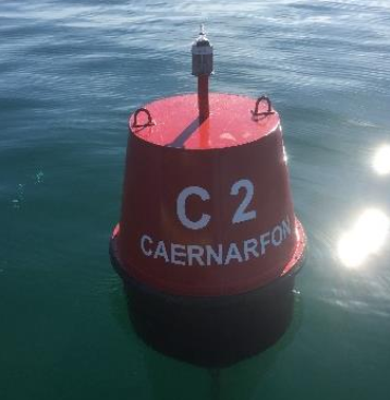
Aid to navigation Port No C2 Fl. R 10s is NOT on its appropriate station
station.
53ᵒ07.12′ N 004ᵒ24.43′ W
Present position: 53ᵒ07.10′ N 004ᵒ24.13′ W
Mariners are advised to navigate with caution in this area.
Local Notice to Mariners 02/2025
10/01/2025 – Y Fenai – Siart 1464 – Menai Strait – Chart 1464
Bar Caernarfon Bar
Nid yw cymhorthydd mordwyo “Graig Dde dwyrain” Ynys Llanddwyn Cardinal De, Melyn a Du ar ei safle priodol.
53ᵒ08.04′ Gog 004ᵒ24.46′ Gor
Cynghorir morwyr i fod yn ofalus iawn yn y ardal hwn.
Aid to navigation Llanddwyn Island “South East Rock” South Cardinal, Y.B is not on its appropriate station.
53ᵒ08.04′ N 004ᵒ24.46′ W
Mariners are advised to exercise extreme caution in this area.
Local Notice to Mariners 01/2025
10/01/2025 – Y Fenai – Siart 1464 – Menai Strait – Chart 1464
Bar Caernarfon Bar
Mae cymhorthydd mordwyo Port Rhif C2 Fl.R 10s nawr ar ei safle priodol.
53ᵒ07.102′ Gog 004ᵒ24.133′ Gor
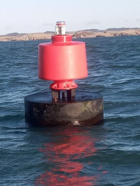
Aid to navigation Port No C2 Fl.R 10s is on its appropriate station.
53ᵒ07.102′ N 004ᵒ24.133′ W
Local Notice to Mariners 29/2024
05/11/2024 – Y Fenai – Siart 1464 – Menai Strait – Chart 1464
Bar Caernarfon Bar
Nid yw cymhorthydd mordwyo Bwi Drylliad yn nodi Castell Grampian Fl (4) Y10s ar ei safle priodol.
Y safle siartredig llongddrylliadau yw 53ᵒ07.30′ Gog 004ᵒ22.98′ Gor
Mae’r cymhorthydd mordwyo wedi derfynwyd dros dro ar gyfer y gaeaf.
Aid to Navigation Temporary Wreck Buoy marking the Grampian Castle Fl(4) Y10s is not on station.
The Wreck’s charted position is 53ᵒ07.30′ N 004ᵒ22.98′ W
The Aid to navigation has been temporarily discontinued for the winter.
Local Notice to Mariners 28/2024
05/11/2024 – Y Fenai – Siart 1464 – Menai Strait – Chart 1464
Bar Caernarfon Bar
Nid yw cymhorthydd mordwyo Bwi Tramwyo L FL 10s ar ei safle priodol.
53ᵒ06.95′ Gog 004ᵒ25.14′ Gor
Mae’r cymhorthydd mordwyo wedi derfynwyd dros dro ar gyfer y gaeaf.
Aid to navigation Fairway Buoy L FL10s is not on station.
53ᵒ06.95′ N 004ᵒ25.14′ W
The Aid to navigation has been temporarily discontinued for the winter.
Local Notice to Mariners 27/2024
22/10/2024 – Y Fenai – Siart 1464 – Menai Strait – Chart 1464
Y Fenai – Menai Strait
Mae yr cymhorthydd mordwyo Traeth Gwyllt Fl (2) G.10s ar ei safle priodol.
Mae’r safle siart bwiau yn 53ᵒ09.232′ Gog 004ᵒ16.116′ Gor
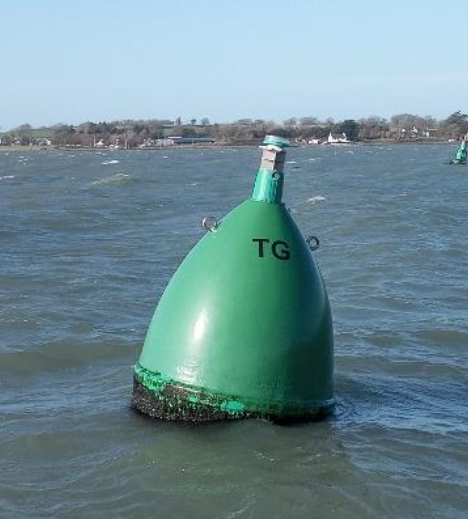
Aid to Navigation Traeth Gwyllt Fl(2) G.10s is on Station.
The buoys charted position is 53ᵒ09.232′ N 004ᵒ16.116′ W
Local Notice to Mariners 26/2024
21/10/2024 – Y Fenai – Siart 1464 – Menai Strait – Chart 1464
Y Fenai – Menai Strait
Nid yw cymhorthydd mordwyo Traeth Gwyllt Fl (2) G.10s ar ei safle priodol.
Mae’r safle siart bwiau yn 53ᵒ09.232′ Gog 004ᵒ16.116′ Gor
Cynghorir morwyr i fordwyo gyda gofal yn yr ardal hon.
Aid to Navigation Traeth Gwyllt Fl(2) G.10s is not on station.
The buoys charted position is 53ᵒ09.232′ N 004ᵒ16.116′ W
Mariners are advised to navigate with caution in this area.
Local Notice to Mariners 25/2024
26/09/2024 – Y Fenai – Siart 1464 – Menai Strait – Chart 1464
Bar Caernarfon Bar
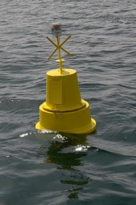
Mae cymorth mordwyo Bwi Banc Cregyn Gleision Fl(2) R 5s wedi terfynu.
Aid to navigation Mussel Bank Buoy Fl(2) R 5s has been discontinued.
Local Notice to Mariners 24/2024
30/08/2024 – Y Fenai – Siart 1464 – Menai Strait – Chart 1464
Bar Caernarfon Bar
“BANC CREGYN GLEISION”
Mae nawr Cymorth Mordwyo Port newydd ar Mussel Bank, ac mae bellach yn dangos siâp dydd priodol a golau Fl R(2)5s yn y sefyllfa ganlynol.
53ᵒ07.320′ Gog 004ᵒ20.926′ Gor
“MUSSEL BANK”
A new fixed Port Aid to Navigation on Mussel Bank, has been completed and is now demonstrating an appropriate day shape and light Fl R(2)5s is the following position.
53ᵒ07.320′ N 004ᵒ20.926′ W
Local Notice to Mariners 23/2024
26/07/2024 – Y Fenai – Siart 1464 – Menai Strait – Chart 1464
Aber Seiont
Hysbysiad o newid dros dro i weithdrefnau gweithredu presennol Pont Yr Aber.
Ar 31/07/2024
Mae gwaith cynnal a chadw yn cael ei wneud ac mae angen cais 30 munud ymlaen llaw er mwyn i’r bont gael ei hagor i draffig yr afon.
01286 672484
07917 244176
Ar gyfer llong sydd angen hafan ddiogel:
Cysylltwch â’r Doc Feistr. Ch 80
01286 672346
Notice of temporary change to current operational procedures at the Aber Swing Bridge.
On the 31/07/2024
Maintenance is being undertaken and a 30-minute advanced request is required in order for the bridge to be opened to river traffic.
01286 672484
07917 244176
For vessel requiring safe haven:
Please make contact with the Dock Master. Ch 80
01286 672346
Local Notice to Mariners 22/2024
25/07/2024 – Y Fenai – Siart 1464 – Menai Strait – Chart 1464
Caernarfon
Ar ddydd Sadwrn 27 a dydd Sul 28 o Orffennaf Mae Harbwr Caernarfon yn cynnal y OCRDA Rasio Cychod Pŵer blynyddol.
Cynghorir Morwyr y bydd rasio cychod pŵer yn yr ardal tu allan i’r Afon Seiont a Doc Fictoria. Bydd oedi posibl mewn gall llywio i mewn ac allan o’r Afon Seiont a Doc Fictoria. Byddwch yn amyneddgar a dilynwch geisiadau’r swyddogion os gwellwch yn dda.
Mae mordwyo y tu mewn i’r ardal GLAS yn gwahardd yn llym yn ystod yr amseroedd rasio.
Cysylltwch â Meistr Doc am ragor o wybodaeth ar y diwrnodau rasio. VHF ch 80.
Gwelwch y PDF am y manylion
On Saturday the 27th and Sunday the 28th of July Caernarfon Harbour is hosting the annual OCRDA Powerboat racing.
Mariners are advised that there will be Powerboat and Jet ski racing in the area outside the River Seiont and Victoria Dock There will be potential delays in being able to navigate inbound and outbound of both the River Seiont and the Victoria Dock. Please be patient and follow the official’s requests.
Navigation inside the BLUE area is strictly prohibited during the racing times.
Please contact the Dock Master on VHF ch80 for further info on the race days.
Mariners are advised to exercise extreme caution in this area.
See PDF for full details
Longterm Notices to Mariners
Local Notice to Mariners 11/2025
01/04/2025 – Y Fenai – Siart 1464 – Menai Strait – Chart 1464
Bar Caernarfon Bar
Longddrylliad “Grampian Castle” Wreck
Mae Cardinal De sefydlog Nnewydd LFl(6) 10s (Castell Grampian) wedi’i osod ar longddrylliad “Grampian Castle”.
53ᵒ07.30′ Gog 004ᵒ22.99′ Gor
A new Fixed South Cardinal LFl(6) 10s (Grampian Castle) has been affixed to the wreck of the “Grampian Castle”.
53ᵒ07.30′ N 004ᵒ22.99′ W
Local Notice to Mariners 24/2024
30/08/2024 – Y Fenai – Siart 1464 – Menai Strait – Chart 1464
Bar Caernarfon Bar
“BANC CREGYN GLEISION”
Mae nawr Cymorth Mordwyo Port newydd ar Mussel Bank, ac mae bellach yn dangos siâp dydd priodol a golau Fl R(2)5s yn y sefyllfa ganlynol.
53ᵒ07.320′ Gog 004ᵒ20.926′ Gor
“MUSSEL BANK”
A new fixed Port Aid to Navigation on Mussel Bank, has been completed and is now demonstrating an appropriate day shape and light Fl R(2)5s is the following position.
53ᵒ07.320′ N 004ᵒ20.926′ W
Local Notice to Mariners 19/2021
02/07/2021 – Y Fenai – Siart 1464 – Menai Strait – Chart 1464
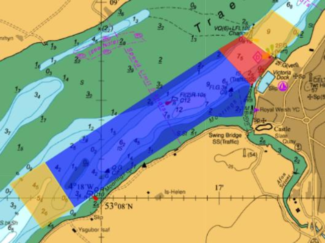
Cynghorir morwyr bod yr ardal a amlygir isod ar y siart, yn benodol o amgylch C7 ac C12 wedi datblygu banc tywod sydd rhyw 1 metr yn uwch na Chart Datwm.
Cynghorir morwyr i gymryd rhybudd a rhoi sylw dyledus i’r dyfnder dŵr sydd ar gael wrth fordwyo yn yr ardal hon.
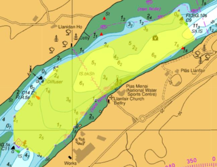
Mariners are advised that the area highlighted below on the chart, specifically around C7 and C12 has developed a sand bank that is approximately 1 meters above Chart Datum.
Mariners are advised to take caution and have due regard for the available depth of water when navigating in this area.
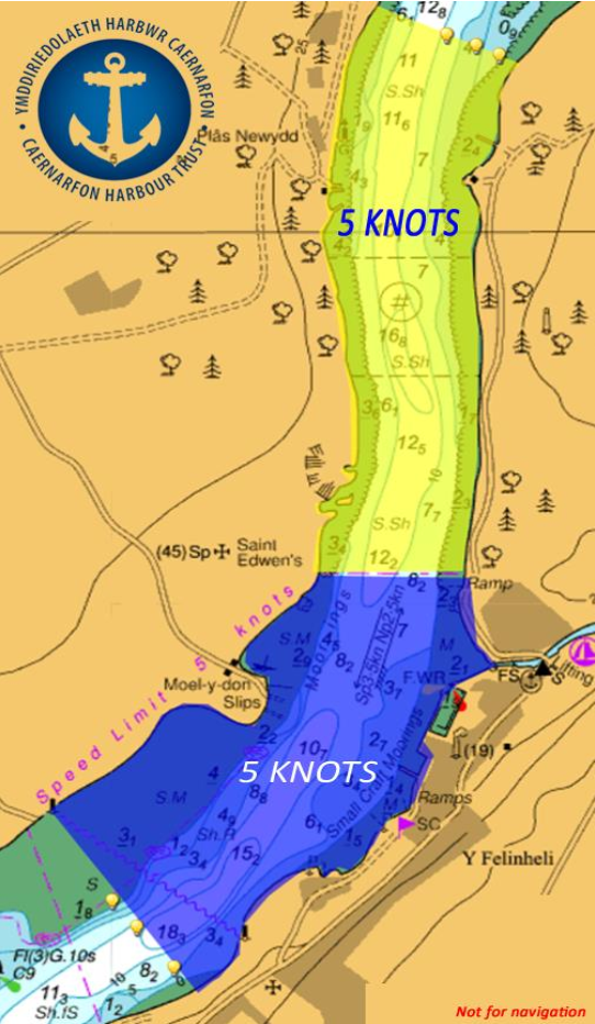
Local Notice to Mariners 12/2021
01/04/2021 – Y Fenai – Siart 1464 – Menai Strait – Chart 1464
Harbour Master’s General Direction
5 Knot Speed Limit
By virtue of the provisions of Sec. 52 Harbour, Docks and Piers Clauses Act 1847, Port and harbour of Caernarfon Harbour Master has made the following General Direction:
1. This Direction is given to Masters (see note a) and persons having command or charge of any vessel (see note b) other than those vessels listed in paragraph 4(i) to 4(v).
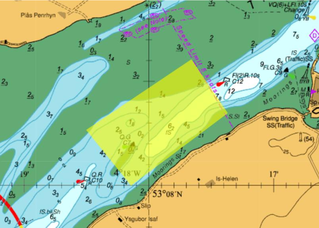
2. This Direction applies at all times and in the area north of the existing and active speed limit at Y Felinheli. (Now known as the “Y Felinheli to Garreg Ginnog” Area of General Direction). The “Y Felinheli to Garreg Ginnog” means the area below the level of mean high water spring tides bounded by a line drawn along the northern extent of the existing charted speed limit at Y Felinheli and through to a new line drawn from a point 53ᵒ12.30’N 004ᵒ12.44’W to a point 53ᵒ12.40’ N 044ᵒ12.82’W. (Illustrative chart extract at end of NtoM).
3. At the Northern and Southern extent of the entire speed limit. Special Marks will be positioned to demark the area.
4. This Direction is not given to Masters and persons having command or charge of vessels:
(i) used by search and rescue organisations
(ii) of the Caernarfon Harbour Authority
(iii) of HM Customs and Excise
(iv) vessels under sail.
(v) used as safety boats by Yacht and Sailing Clubs and other such organisations when engaged in operations where complying with this Direction would inhibit their ability to fulfil their function as a safety boat
5. No vessel, except those listed in paragraphs 4(i) to 4(v), shall proceed at a speed of greater than 5 knots.
6. This Direction is given notwithstanding the requirements of the International Regulations for Preventing Collisions at Sea (see note c) and The Port and Harbour of Caernarfon Bylaws 1991 (see note d).
7. Not to comply with this Direction is a criminal offence for which the person having command or charge of the vessel may be prosecuted (see note e).
8. The Harbour Master or his deputies will be actively monitoring the compliance with this General Direction.
David John O’Neill
Caernarfon Harbour Master
Notes
a Sec.3 Harbour, Docks and Pier Clauses Act 1847
b As defined in the Port and Harbour of Caernarfon Bylaws 1991.
c Merchant Shipping (Distress Signals and Prevention of Collisions) Regulations 1996 [SI 75/1996]
d Port and Harbour of Caernarfon Bylaws 1991.
e Sec.3 and Sec.53 Harbour, Docks and Piers Clauses Act 1847
Owners, Agents Charterers, Marinas, Yacht Clubs and Recreational Sailing Organisations should ensure that the contents of this Notice are made known to the master or persons in charge of their vessel or craft.
Blue area denotes existing speed limit. Yellow area denotes new area of General Direction.
Local Notice to Mariners 14/2019
16/05/2019 – Y Fenai – Siart 1464 – Menai Strait – Chart 1464
Menai Strait
Cynghorir morwyr bod yr ardal a amlygir isod ar y siart, yn benodol o C11 er i C9 wedi datblygu banc tywod sydd rhyw 0.5 metr o ddŵr yn is na Chart Datwm.
Cynghorir morwyr i gymryd rhybudd a rhoi sylw dyledus i’r dyfnder dŵr sydd ar gael wrth fordwyo yn yr ardal hon.
Mariners are advised that the area highlighted below on the chart, specifically from C11 though to C9 has developed a sand bank that has approximately 0.5 meters of water below Chart Datum.
Mariners are advised to take caution and have due regard for the available depth of water when navigating in this area.